The world in figures: land area
Interactive
Diagram:
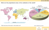
What are the proportional areas of the continents of the world?
Type of media:
Interactive (474.9 kByte)
Last update:
2021-06-25
License:

This medium is made available under a CC BY-SA 4.0 international license.
What does this mean?
How to reference this medium

This medium is made available under a CC BY-SA 4.0 international license.
What does this mean?
How to reference this medium
Description:
The distribution of the world’s land area on the individual continents is shown as a pie chart. The “pieces of pie” can be labeled interactively with the names of the continents and their proportion of the earth’s land area (in square kilometers).
Information and ideas:
The proportional shares of the earth’s total land area are given in the information in the medium.
Please note: There are various models on the number and division of continents.
Information and ideas:
The proportional shares of the earth’s total land area are given in the information in the medium.
Please note: There are various models on the number and division of continents.
Learning resource type:
Illustration
Subjects:
Personal, social and health education (PSHE)
Grade levels:
Grade 1 to 4
School types:
Elementary school
Keywords:
Africa; America; Antarctica; Asia; Earth's surface; Europe; Oceania
Bibliography:
Siemens Stiftung Media Portal
Author:
MediaHouse GmbH
Rights holder:
© Siemens Stiftung 2020


